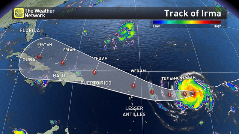
As Hurricane Irma, a worrisome category 3 hurricane, is expected to strengthen in the Atlantic as it moves towards the Leeward Islands, authorities have warned the US mainland to be prepared should the storm head that way.
As of Monday morning, Irma remains at Category 3 status - moving west-southwest with winds nearing 115 mph - with the potential to reach Category 4 status by the end of the week, according to the Weather Network.
"Interests in the remainder of the Leeward Islands, the British and U.S. Virgin Islands, Puerto Rico, and the Dominican Republic should monitor the progress of Irma, " said the National Hurricane Center in a statement Monday morning. "Additional hurricane and tropical storm watches and warnings will likely be required for portions of this area later this morning or this afternoon."
The center of Irma is located 610 miles east of the Leeward Islands, and over the next five days is expected to move west-southwestward, then west-northwest on the south side of a ridge of high pressure called the Bermuda high, centered in the central Atlantic.
By next weekend, however, Irma will "begin to turn north in the direction of a departing southward dip in the jet stream that will set up in the eastern United States. Where that northward turn occurs will be critical for what impacts parts of the United States may see from Irma," according to weather.com.
The outlet notes it's "far too soon to speculate on the specifics surrounding any potential U.S. threat from Irma," but acknowledges the storm could "pose a big danger as it draws closer later this week."
"For now, all residents along the East Coast and Gulf Coast should monitor the progress of Irma. Locations from Florida into the Southeast U.S. have the potential to see impacts from Irma first, but that is subject to change," reports the outlet.
"Destructive winds, storm surge inundation, pounding surf and heavy rainfall could all be potential threats from Irma. Determining where those impacts will occur and how serious they may be is too early to determine."
CNN meteorologist Taylor Ward also said it was too early to predict Irma's threat to the United States.
"As for what we do know, the system will approach the northern Leeward Islands late Tuesday or early Wednesday, likely as a major hurricane of Category 3 or more. It's still unclear if these islands will take a direct hit or just be brushed by the outer bands of the storm," he said.
"Beyond the northern Leeward Islands, the storm could approach the Turks and Caicos and Bahamas by late week, but again nothing is certain for these regions."
Nevertheless, in a series of tweets Sunday, Florida Gov. Rick Scott urged the state's residents to ensure their disaster supply kits were ready.
"FL knows how important it is to be prepared. Encourage your loved ones to have a plan ahead of any potential storm," Scott tweeted. "Disaster preparedness should be a priority for every Florida family."
Potential Impact Timing
-
Leeward Islands: Late Tuesday-Wednesday
-
Puerto Rico/Virgin Islands: Wednesday-Thursday
-
Dominican Republic/Haiti: Thursday-Friday
-
Turks and Caicos: Thursday-Friday
-
Bahamas: Friday-next weekend
-
Cuba: Friday-next weekend
CNN reports that Irma is a classic "Cape Verde hurricane," which frequently become some of the largest and most intense hurricanes. A hurricane watch, issued two days in advance of tropical storm force winds, means sustained winds of 74 mph or higher are possible. You can track the storm path here.


