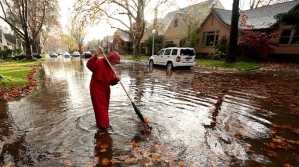
California may be in the midst of a long-term drought, but the northern part of the state could be walloped with a strong, wet storm.
According to the National Weather Service, the storm is expected to arrive Wednesday and pelt the San Francisco Bay Area region through Thursday with high winds and flash floods. The Associated Press reported that heavy rainfall is expected, especially in the North Bay.
The National Weather Service in Monterey, Calif. said that this particular storm is "expected to be one of the strongest storms in terms of wind and rain intensity" since storms dating back to October 2009 and January 2008 respectively. The organization also reported that the heaviest rainfall totals are expected from western Washington to Northern California, with an expected total between 3 and 5 inches.
The director of the California Governor's Office of Emergency Services, Mark Ghilarducci, issued a warning that certain areas may experience flash flooding and debris slides.
"This year was also a significant fire season for Northern and Southern California and burned areas are especially at risk for debris slides," Ghilarducci said in a statement. "Even regions that don't experience regular seasonal flooding could see flash flooding during this intense storm system, which could be the largest to date of this year's rainy season."
Veronica Rocha of the Los Angeles Times reported that the weather service issued blizzard warnings too. The warning applies to communities above 6,000 feet, including Lassen National Park, Donner Pass, Echo Summit and Carson Pass.
"The warning will be in effect from 10 p.m. Wednesday until 1 p.m. Friday," Rocha wrote. "The weather service said residents could expect whiteout conditions, which could lead to roadway closures lasting several hours."
According to the National Weather Service, the upcoming storm will dump up to 7.69 inches of rain in the Sierra Nevada and more than 3 inches in the Bay Area. In addition, there could be wind gusts reaching up to 40 mph along the coast and more than 60 mph in the mountains, creating hazardous driving conditions.
"This storm still looks like it could be the strongest storm we've seen in several years," the National Weather Service office in Sacramento said.
The upcoming weather event, known as the Pineapple Express on the West Coast, occurs when atmospheric rivers, which are relatively narrow regions in the atmosphere, transport water vapor horizontally outside the tropics, according to the National Weather Service.
However, meteorologist Scott Sukup told the Los Angeles Times that other parts of California will be affected by the storm too. The counties of Los Angeles and Ventura could get 1 to 2 inches of rain along the coast and 2 to 4 inches in the mountains and foothills around the same time period.
"It will be a pretty significant rainfall event for us," Sukup said.
Officials from the California Highway Patrol and California Department of Transportation warned drivers in a Sacramento Bee article to expect very difficult conditions on local and mountain roads starting on Wednesday night. To prepare for the storm, drivers should fill up their gas tanks, check windshield wipers and replace if necessary, avoid using cruise control, plan alternate routes, or delay the trip entirely if it is not necessary.
Around the home, the Sacramento Bee suggests preparing a simple emergency kit such as a flashlight, battery-operated clock and radio, extra batteries, manual can opener and supply of bottled water. In addition, loose leaves should be picked up to reduce risk of street flooding, grates should be monitored to keep water flowing, and loose items such as patio furniture and Christmas decorations should be brought inside.
The Los Angeles Times reported that most of the heavy rain should taper off by Friday morning.


